
* * * * *

Flag of Vietnam.
Saigon, Socialist Republic of Vietnam (SRV)
Friday, 24th November 1995
On the above date I found myself once again returning to Saigon. Climbing to 25,000 feet in the early morning, I followed airway W-76, which in turn paralleled the snaking Mekong River off our right side, as we headed south.


The Mekong begins its journey from the
Tibetan Plateau and flows through China, Burma, Laos, Thailand, Cambodia, and Vietnam, before emptying into the South China Sea. Flowing a distance of 2,730 miles makes it
the world’s 12th- longest river, and the 7th-longest in
Asia.
For a thousand years this river has been used in commerce, moving people
and goods, just as my 737 was doing this day following it south bound.
And for you fishermen, dear
reader, please note this:
No other river is
home to so many species of oversized fish. The biggest include three species of Probarbus barbs,
which can grow up to 4.9 feet and weigh 150 pounds, the giant freshwater
stingray, which can reach at least 16 feet in length and
6.2 feet in width, plus the giant pangasius, giant barb and the famous Mekong giant catfish. These last
three can grow up to 9.8 feet in length and weigh 660 pounds.

Which reminds me of a theory I have, dear
reader: If I can avoid playing golf, or fishing, I’ll never grow old.
And as we
continued southbound, I became aware of an excessive amount of air traffic
passing over the top of us, either eastbound or westbound. Laos was proving itself to be the aerial shortcut
to Europe, Africa, the Middle East, India, or Asia. This is why we were restricted to the low
cruising altitude of 25,000 feet, in order for all of this air traffic to pass
over us above 30,000 feet.
Thus it occurred to me, dear reader, that
Vientiane should be the base for a major international airline. From a logistics point of view it was the
perfect location; making me wonder if the Laotian Government would ever figure
this out.
Upon reaching the Pakse VOR we crossed the
Mekong River - entering Cambodian airspace – turned to a southwest heading, intercepting
airway B-329, which placed the twisting Mekong off our left side.

Thirty-two minutes
later we converged with the Mekong again, as we crossed over the capitol city
of Phnom Penh resting on the banks of this river. At which point we made a sharp left turn to a
southeast heading, joining airway R-468, for the short, 26-minute run, to
Saigon.
The weather was
clear that morning, and I had no trouble visually spotting Tan Son Nhat Airport
at 15 miles out. Advising the tower we
had the airfield in sight, they cleared us for the visual approach to Runway
Two-Five Right.

If
you’ll remember, dear reader, Tan Son Nhat had parallel runways (070°/250° magnetic,
NE/SW); the north runway being 10,000 feet in length, and the south runway
measuring in at 9,961 feet long.
After executing a
downwind leg and base leg, I intercepted the Localizer and glideslope outside
the Outer Marker, and began my final approach to Runway Two-Five Right.

After passing the
Outer Marker, and descending through 900 feet at less than three miles on
final, I crossed a small river. This was
a snaking tributary off the main Sóng Sái
Gón River, which the locals named the Vam Thuat River (formerly called Ben Cat). What grabbed my attention out my left side
window was an island barely the size of a city block, in the middle of this
river, which was heavily overgrown with all manner of vegetation. Despite the thick foliage, I could clearly
make out the tiled roof of, what I thought was, a private villa.
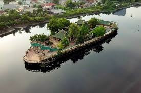
Naturally this fired up my wild
imagination, dear reader. Making me
wonder what corrupt Communist Commissar, or river pirate, was working out of
such perfect, isolated digs for nefarious activities. In contrast, due to the overgrowth in need of
gardening, the island held a rather melancholy, sadly neglected quality in its
appearance.

Years afterwards I had the opportunity to research
this mysterious island in the heart of Saigon, learning my original deductions
couldn’t have been more wrong:
There doesn’t exist any official records of the island; only handed-down, local, oral folklore. According to this, in the 18th or 19th centuries, a local fisherman pulled in his net, and, among the fish, uncovered the nude body of a drowned young woman.

To respect her spirit, he
carefully buried her on this uninhabited islet, and built a shrine over the
grave of bamboo and coconut palm fronds.
During the decades that followed, the locals constructed a proper shrine
out of bricks, mortar and tiles. It came
to be called the Chau Phu Temple, or “floating shrine.”
After 1975 the island and shrine became abandoned; the reason for its
sad state of neglect when I originally discovered it. In the near future though, it would be
rediscovered and properly maintained as a tourist attraction.
I still prefer my story of it
being the headquarters of a nefarious river pirate, dear reader. On the other hand, it’s always struck me as
odd, how my mind can spot stuff on the ground, while busily flying an
instrument approach on low final, when it should be occupied with far more
important data. Like staying alive! This can’t be normal.
Upon landing at Tan Son Nhat Airport, we covered the 659 NM (757.8 SM) in an hour and forty-six minutes, and, upon parking at stand #24 on a vacant ramp roughly 200 meters from the tired terminal, I’m now faced with a serious problem: TIME.

As one can
appreciate, I don’t have time for any screw-ups or general “dicking around.” Which brings me face-to-face with my problem:
I am not fluent in Laotian, Thai, Cambodian, Burmese, Chinese or Vietnamese. So how can I possibly direct the ground
staff, in all these countries, as to how much fuel to put in all three of my
tanks, or how to load the baggage and freight in my forward and aft baggage
compartments? If it’s loaded wrong,
placing my 737 outside the center of gravity envelope, I can easily stall-out
on takeoff - rolling us upside down – spreading all of us across rice paddies
for miles!
Relax, dear reader, all is not lost. Actually, the solution to my
communications-logistics dilemma proved to be quite simple.
Regarding refueling: In the 737 cockpit there is three fuel gauges in thousands of pounds: Left Wing Tank, Center Tank, and Right Wing Tank.

Outside the 737, underneath the right wing, there is a refueling panel. When the panel is pulled down, identical fuel gauges are revealed.


Therefore, using my
laptop and compact printer back at the hotel beforehand, I replicated these
three fuel tank gauges as a series of three circles, in a row, filling up a
sheet of paper with them. When it was
time to issue refueling instructions, I merely wrote the amount of fuel for
each tank; Left Wing: 9,000 Lbs., Center: 12,000 Lbs., Right Wing: 9,000
Lbs. Then took a chart plotter and
ripped off that strip of paper with the fueling figures for all three tanks.

As for baggage and freight loading: This was even easier and already to go. Using my laptop, I drew the 737 in a right side profile; the side containing the aircraft’s fore and aft cargo compartment doors. In the foreground, I drew a pile of baggage and freight in a neat stack, plus a vertical, segmented line cutting the load in half. Then I drew an arrow going from the left half of the load to the aft cargo compartment; and another arrow from the right half of the load to the forward cargo compartment.

By dividing the baggage and freight equally in half between the cargo
compartments, and using five units of elevator trim, we were always within the
center of gravity for takeoff. Once
again I filled up a page of paper with these illustrations, in order to tear
them off in single strips.
Now for the
delivery system: A clear plastic drinking cup, of the type all airlines carry
for their passengers.


As for the
refueling strip, I rolled it up and slipped it into the afore-mentioned plastic
cup. Then I slid my left side window
open, and glanced straight down, discovering about 15 feet below a little,
sweating local patiently waiting for me in the fuselage’s shade. I dropped the plastic cup...he caught it and
pulled out the paper, examined it, then looked up at me with a toothy grin and
a thumbs-up. After which he scuttled-away
at a dead run to his refueling tanker-truck, previously hooked up to the
center-point refueling receptacle, under the right wing.
As for the baggage
and freight loading slip, I’d repeat the same procedure with the plastic cup,
dropping it into the hands of the waiting cargo-loader.
I can honestly swear, dear reader, by using
this rudimentary method, not once did any of the ground crews in all these
Southeast Asian countries screw up a refueling or freight loading
instruction. Nor did they cause me any
delays; without having to say a single word to them I consistently departed on
schedule.
*
* * *
*


Comments
Post a Comment