
* * * * *
My captain for the trip that evening was Terry Kemp, a highly qualified and most pleasant British gentleman in his early forties. The flight engineer, Mr. Tan, was an efficient thirty-year-old Singaporean. Following their appearance at dispatch, came a surprise in the form of John Maguire, another Brit. He was short in stature, with dark hair, and politely informed me he was my “training first officer.”

Under the FAA system, line training was
always performed by a training captain. Surprisingly,
under the CAAS system, this chore could be performed by a senior first officer;
when training a new-hire first officer.
John proved to be a professional, with a lot of 747-experience, and had
no problem with my performance during the succeeding nine days. At the end of this trip, he would recommend
me for a line qualification check ride.

We launched on schedule after dark, operating SIA Flight 36, nonstop to the Maldives. Climbing the 747-212 at Mach 0.82, to 31,000 feet and cruising at Mach 0.84 (569 mph), gave us an en route flight time of 4:48 hours. Our PAX-Load was 366 passengers, with a crew of 21 – totaling 387 souls on board.

Since it was my leg, dear reader, I had all these souls in my hot, sweaty, helicopter pilot hands. So how did I cope with the stress this responsibility produced? I concentrated on my little world inside the cockpit – keeping it safe and intact -ignoring, and forgetting, what lay on the other side of the cockpit’s door. As I’ve indicated before, my brain is wired oddly. However, this mental exercise did in fact alleviate my stress; allowing me to think clearly and accurately. Only when I left the cockpit to use the restroom, or take a stroll to wake me up, did the responsibility for all these hundreds of slumbering bodies come crashing in on me. Prompting a hasty retreat to the “sanctuary” of my cockpit; where I could get busy and forget what lay on the other side of the cockpit door.


Singapore sat roughly 82 nautical miles north of the equator, requiring us to travel northwest - up the heart of the Malacca Strait between Malaysia and Indonesia – to Medan in Indonesia. Then slice across the Island of Sumatra - setting up a westbound track along the southern edge of the Bay of Bengal – paralleling the equator to the south of us.
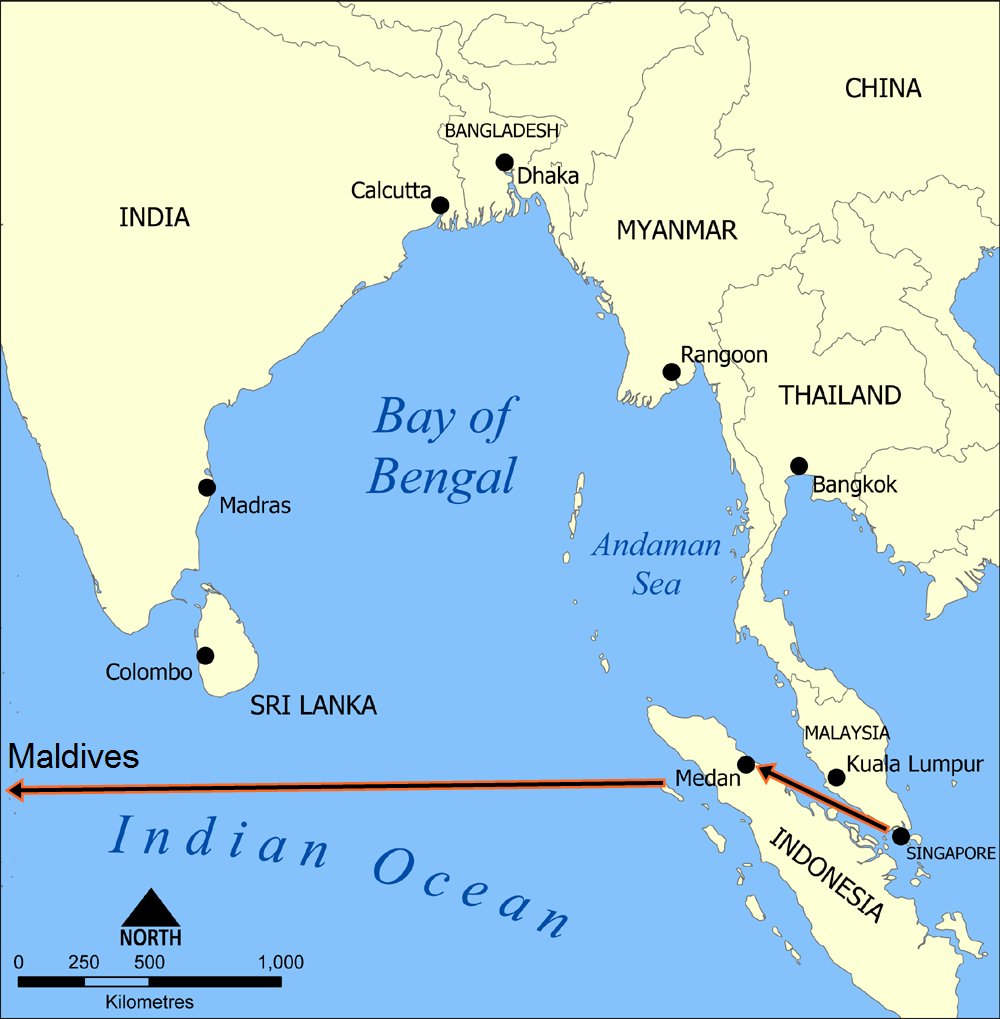
Now it was a straight run to Malé -
the capitol of the Maldives – located 327 nautical miles southwest of the
southern tip of India, and 251 nautical miles north of the equator.

It was black as pitch outside my cockpit window; not allowing much in
the way of “sightseeing.” And as we
traveled across all that dark water below – locked between the Bay of Bengal
and the Indian Ocean – we made position reports on HF Radio, first with Jakarta,
and later with Colombo.
While we did this, dear reader, a
cold realization occurred to me. Should
we disappear in those black churning seas below; not a soul would know about
it. Why?
Neither Indonesian ATC, nor Sri Lankan ATC, had any radar coverage of
these waters. Perhaps their military
radar might spot us – but they aren’t required to track us - and we have no way
of contacting them. Frankly we’re
totally on our own. This isn’t Kansas
anymore, Dorothy.
Pushing these morbid thoughts aside, I got busy “feeding the
animal.” We have three, Delco Inertial
Navigation Systems (INS) onboard, directing our autopilot where to go. Nevertheless, because this is a 747-212,
these earlier Delco models are restricted to nine waypoints at once. Therefore, as we use these waypoints up, we
have to keep loading more waypoint positions up ahead - inserting their
latitude and longitude coordinates as we go – known as “feeding the animal.”


When I was initially checked out at SAUDIA, my line training captain,
Brian Saunders, informed me of the “INS Graveyard” off the West Coast of Africa;
situated at zero degrees latitude and zero degrees longitude. After crossing the ninth waypoint in the INS
– if no other waypoints have been loaded – the INS will instruct the autopilot
to head for the “INS Graveyard.”

* * * *


Comments
Post a Comment